

If you've been on I-26 heading from NC to TN, you may have seen the rugged cliffs off to the west within Rocky Fork, north of Flag Pond, TN, this is known as White House Cliffs. The links below will show you this view. It's not an especially long hike, just under 1.5 miles each way. But it's one of the harder hikes I've experienced in this area in terms of vertical climb in a short distance. Nothing is hand-over-hand, just a very steep trail. So be prepared for that!
 |
| iPhone panorama of the incredible views (click photo to enlarge) |
Once on top, you can explore and climb down the from the steep, rocky pinnacle to the actual rock outcropping that is visible from the interstate. But from what I've read (again, see links below) this is very difficult and also dangerous to do. But as the dog (and I) were worn out and in need of water, I took some shots from the summit and headed back down the mountain.
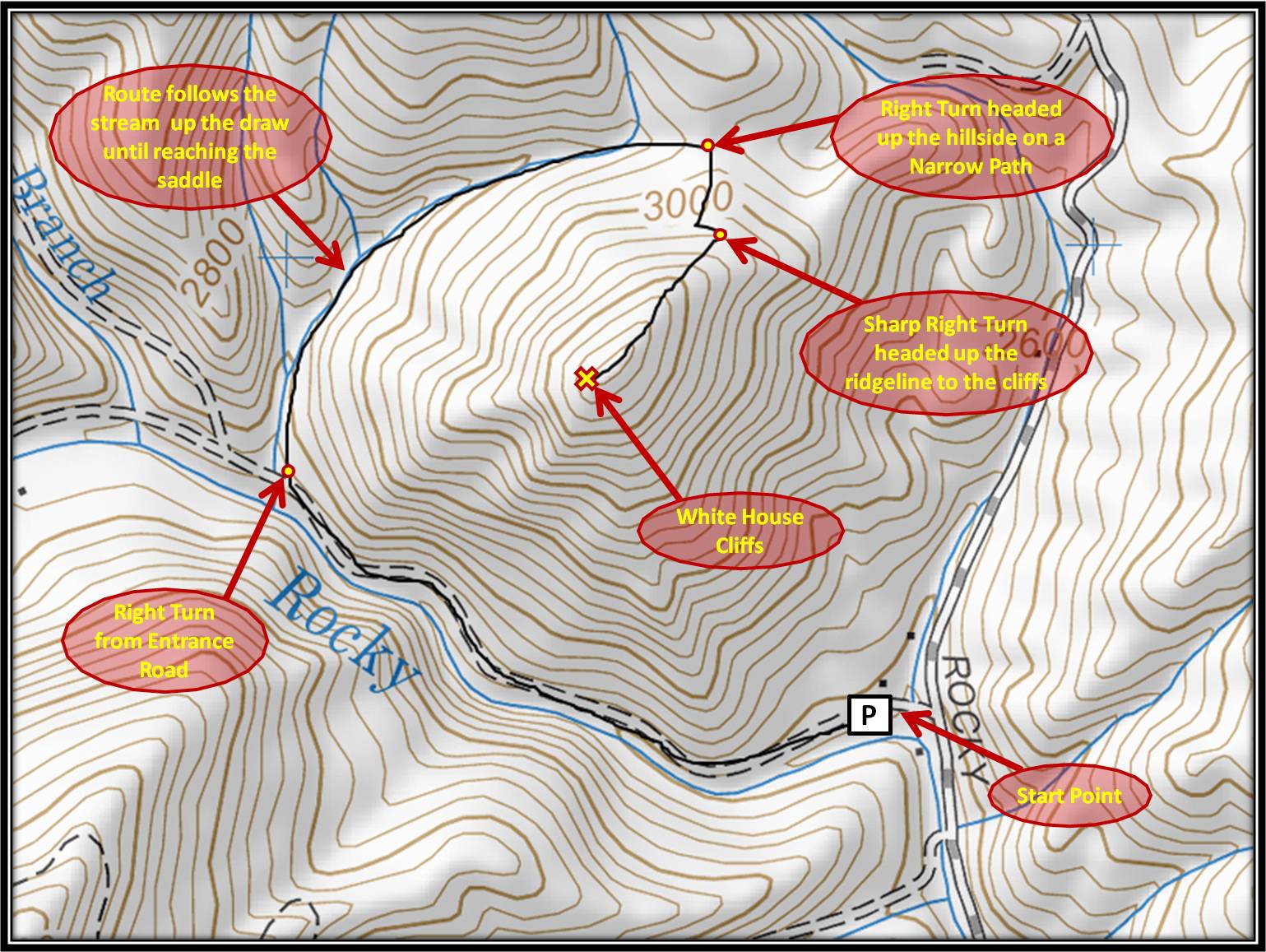
Directions: Take the Flag Pond exit off of I-26 (exit #50), at the stop sign turn left onto Higgins Creek Road. Drive ½ mile, til you reach Rt. 23, turn right and travel 2 ¼ mi. thru Flag Pond, then turn left on Rocky Fork Road. Take your time driving up this road, the creek offers amazing cascades and waterfalls. After ¾ mi. you will see a gravel pull-off to the left and a small parking area. Park here (out of the way of the gate) and follow the gravel lane into Rocky Fork on foot. I think of the trail to the cliffs as broken up into three distinct segments....
 |
| The main road within Rocky Fork |
 |
| White House Cliffs Trail Head |
 |
| Can you see the trail? :) |
 |
| Survey marker where trail takes sharp turn |
Monkey's Mask (scroll down after clicking)
RATreks
Far Outside the Wire
For a terrific map of the White House Cliffs Trail, click here.
For a helpful map giving an overview of the trails of Rocky Fork, click here.
The photo at the very top was my favorite from my trip... and it's from my iPhone. So glad I carried up all my gear only to have the iPhone out-perform my Nikon. Ugh. :P
Update (Spring 2015): The trail has seen more use and is much easier to find and navigate. The best thing you can do is follow study this WH Cliffs Trail map to get your bearings. Wear old shoes for the second section that follows the creek! Very muddy after a rain. We climbed down a bit farther from the top, but it's rough. Rocky, thorny, steep, unsteady. Turned around after a bit. When we got on the interstate headed back home we looked over at the cliffs, and were amazed how far down they are from the top. Glad we didn't continue down to them. From what I've read, it's crazy dangerous to try to head down to the road from the cliffs (which makes sense), so you would have to ascend the peak once again and come back whence you came. :) For me, I'm more than content with the amazing views from the top.
No comments:
Post a Comment
Thanks for visiting and joining in the discussion on Appalachian Treks! Your comment will be sent to me to be approved. Sorry for this added step, but it is necessary to avoid spam. Thanks for taking the time to leave a comment!